A wide range of rain and snow officially opened today! | Early warning
This wave of large-scale rain, snow and freezing weather before the Spring Festival opens today! This large-scale freezing rain and snow weather has a wide range of influences, a large amount of accumulated rain and snow, a long duration and a large freezing rain area, which is the strongest in winter since 2009 and is extreme. ▼
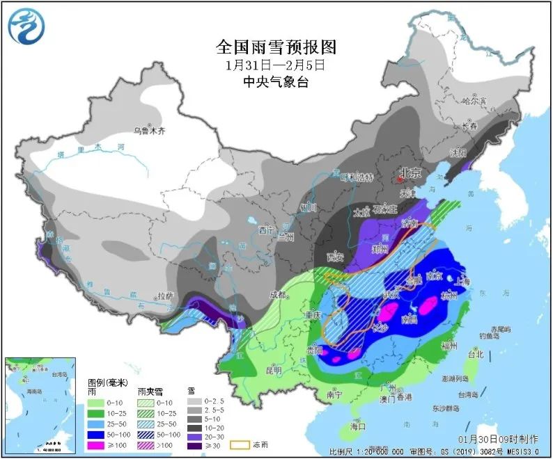
Accumulated rain and snow are heavy and snow is thick. The snowfall in Shaanxi, south-central Shanxi, southern Hebei, Henan, Shandong, Hubei, northern and eastern Chongqing, eastern Liaoning, eastern Jilin and other places can reach 10 ~ 25 mm, and the local area exceeds 30 mm; The newly added snow in northern and eastern Chongqing, northwestern Hubei, southern Henan, central and northern Shandong, eastern Liaoning and other places can reach 10-20 cm, and the local area can exceed 25 cm.
Freezing rain covers a wide range of provinces. From 1st to 4th, there were freezing rains in southern Shandong, southern Henan, central and western Hubei, northern Anhui, northern Jiangsu, northwestern Hunan, eastern Guizhou and other places. The total area affected by freezing rain was 430,000 square kilometers, with the largest impact area and the largest number of provinces since 2009.
The phase transition between rain and snow is complicated. After the process began, there was sleet or rain turning to snow in southwestern Shaanxi, southwestern Shanxi, Henan, southern Shandong, central and northern Jiangsu, central and northern Anhui, Hubei, northern Hunan and other places. On the afternoon of January 31, Shaanxi and Shanxi turned to snow; On the night of the 31 ST, snow turned in northern Henan and southern Shandong; On the afternoon of February 1, most of the above areas turned to snow.
The process lasts for a long time. The duration of the rain and snow process is 6 days, and the duration of rain and snow in Shaanxi, Shanxi, Shandong, Henan, Jiangsu, Anhui and other places is 4-5 days. The rainy weather in some areas in the middle and lower reaches of the Yangtze River can reach 6 days, and the duration of the process is also the longest since 2009.
Break the extreme value of the same period in many places. The cumulative precipitation in some areas such as southwestern Shaanxi, southwestern Shanxi, southern Hebei, Henan, Shandong, Jiangsu, Anhui, Hubei, northern Chongqing, northwestern Jiangxi, and northern Hunan will approach or exceed the historical extreme value in the same period.
The Central Meteorological Observatory issued a blue warning of blizzard at 06: 00 on January 31st: It is estimated that there will be heavy snow in parts of central and northern Shaanxi, central and southern Shanxi, southwestern Hebei, central and northern Henan, southern Shandong and northern Jiangsu from 08: 00 on January 31st to 08: 00 on February 1st, among which there will be heavy snow (10-11 mm) in parts of central Shaanxi, southwestern Shanxi and western Henan. The depth of newly added snow in some areas above is 2 ~ 4 cm, and the local area can reach more than 5 cm. In addition, there are moderate to heavy rains in parts of Shanghai, southern Jiangsu, northern Zhejiang, southern Anhui, northwestern Jiangxi, central and eastern Hubei, western and northern Hunan, and northeastern Guizhou, and heavy rains (50-60 mm) in parts of southern Anhui, northeastern Hunan, and northwestern Jiangxi. ▼
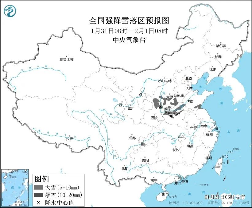
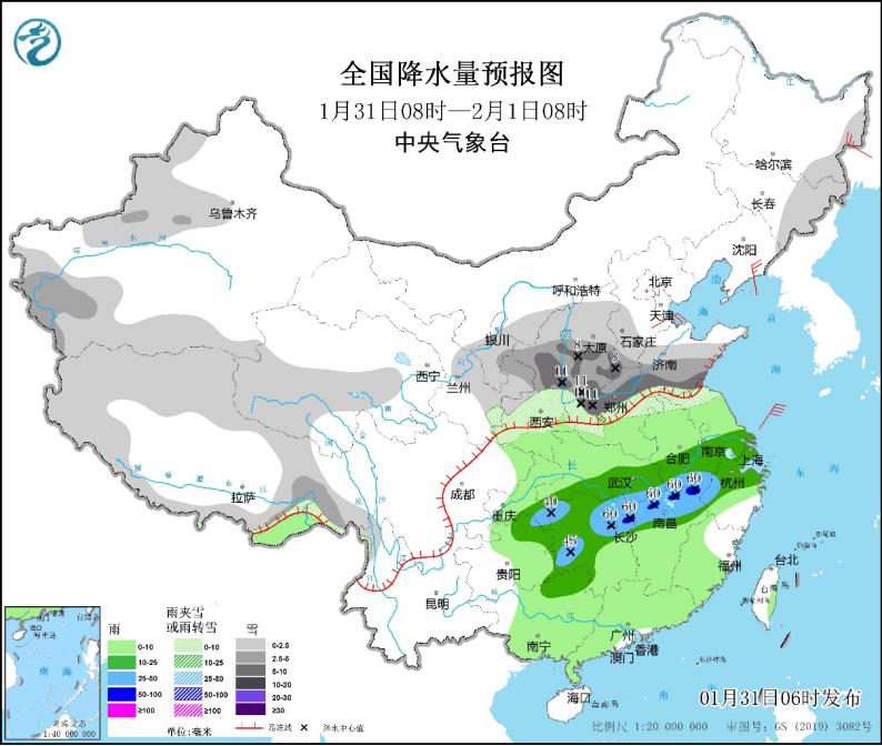
△ National heavy snowfall forecast map and national precipitation forecast map. (08: 00 on January 31st-08: 00 on February 1st)
In addition, the Central Meteorological Observatory continued to issue a yellow fog warning at 06: 00 on January 31: It is predicted that there will be heavy fog in the western waters of the central and southern Yellow Sea, the western waters of the East China Sea, the Taiwan Province Strait, the northern waters of Beibu Gulf, the Qiongzhou Strait, the southern coastal waters of Shandong Peninsula, the coastal waters of Jiangsu, the waters near the Yangtze River estuary and Hangzhou Bay, the coastal waters of Zhejiang, the coastal waters of northern Fujian and the coastal waters of Guangdong from day to night on January 31, with visibility less than 1 km. In addition, from the morning of January 31 to the morning, there were foggy weather in parts of southern Hebei, western Shandong and southern Peninsula, northern Anhui, most of Jiangsu, eastern Zhejiang, northern Fujian, southern Hunan, northwestern Jiangxi, south-central Guizhou and south-central Guangxi. Among them, some areas in southwestern Shandong, eastern Jiangsu, eastern Zhejiang and northwestern Jiangxi had dense fog with visibility less than 500 meters, and local visibility was less than 200 meters.
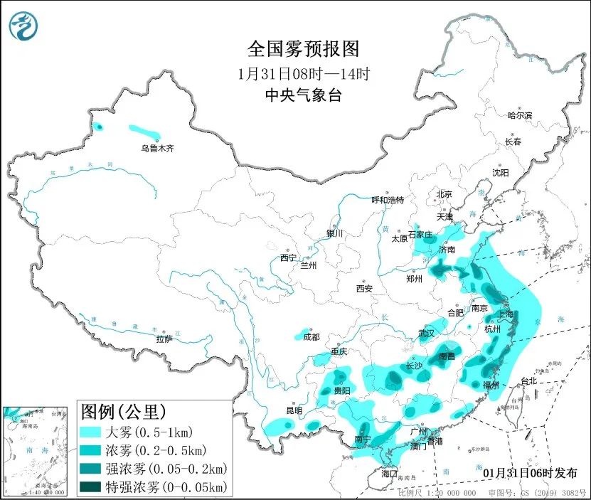
△ National fog forecast map. (08: 00-14: 00 on January 31)
This process coincides with the peak of Spring Festival travel rush’s return home, and the freezing rain and snow will have a heavy impact on Spring Festival travel rush’s travel. Snow, ice and low visibility on roads in the rain and snow will easily lead to traffic jams or accidents on expressways. ▼
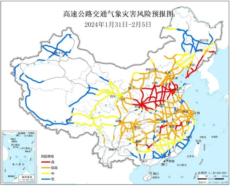
△ Expressway Traffic Meteorological Disaster Risk Forecast Chart (January 31-February 5, 2024)
The Traffic Management Bureau of the Ministry of Public Security reminds the vast number of returnees-
When traveling by car, you should know the origin, destination and weather forecast and warning along the way in advance, as well as the road information released by public security traffic control, transportation, emergency management and other departments, and make a good route planning. At the same time, in view of rain, snow, fog, freezing and other weather, drivers are requested to know the corresponding safe driving knowledge in advance to ensure driving safety!
Driving safely in snowy days ▼
Driving safely in rainy days ▼
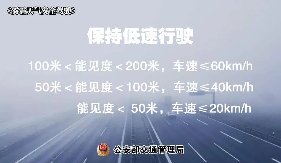
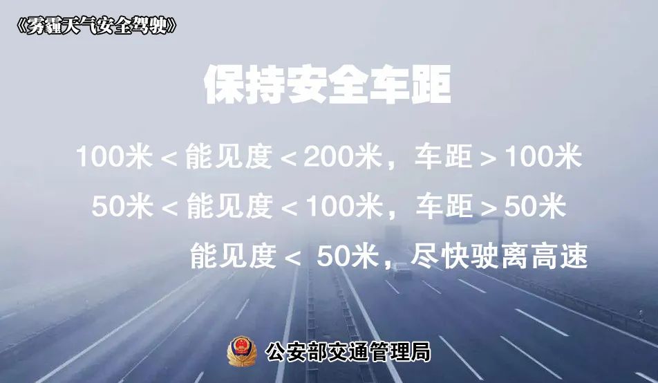
Safe driving in foggy days ▼


Safe driving on ice and snow roads ▼

Original title: "A wide range of rain and snow officially opened today! | Early Warning
Read the original text